Abstract- An analysis of the angular values present in lines carved on various recovered items from Emei Mountain reveals the lines are consistent with the Babel Text. This data is consistent with the study of the Jade Eagle from Lingjiatan. This suggests the Babel Texts was used within China around 5,000 years ago, which overlaps in time with the use of The Babel Texts in Mesopotamia.
Author: Derek Cunningham
Introduction
With the recent combined analysis of the Babel Texts from all know regions and all time periods (from circa 350,000 BC to circa 1,000 AD)1, it was decided to return to the Emeishan Disk2, to determine if the data from this item is consistent with more ancient texts.
Emeishan is located in China, and this region came to my attention as the Eastern Gateway to heaven3. This placement was based on the hypothesis that ancient people may have used the stars for navigation, and because the night sky is known to change each night, as we rotate slowly around the sun, the theory postulated that perhaps the night sky was divided into three distinct regions3.
The advantage of dividing the sky into zones, is perhaps not clear today, but for an ancient civilisation, the advantage is no matter where the Earth is, in its travel around the sun, there would then be a region of the night sky that could then be used for navigation, if the position of the stars could be linked to a location on Earth.
Now that sounds logical, but there is one additional layer to this theory. It is now known that an ancient civilization did one travel the entire surface of our planet within the Stone Age1,3. This is confirmed by the presence of the same ancient linear text in all occupied regions of the world.
It is also known that the astronomical values used in creating this astronomical text are those specifically linked to the measurement of time, and the measurement of time is crucial for navigation, and when the location is known, it becomes possible to create maps.
It was based on all the observation that the same linear geoemtric patterns could be found worldwide, that it seemed reasonable to argue that perhaps the same ancient civilization created a map of Earth, in which the stars were brought down to the surface of the planet to locate specific regions.
In fact, after becoming used to the nightly movement of the stars, it is plausible that someone in the past may have thought it might be amusing to do this.
The strange “coincidence” is the division of the night sky into three distinct zones, and then wrapping the map around Earth three times does seem to match a primary historical site, and the ancient legends that surround the Greek constellations. The first overlap is the proposed alignment of the proposed map is consistent with the layout of the Great Pyramids, and the theory that the Great Pyramids were designed to mimic the shape of constellation Cygnus the Swan, and the second is when the stars are wrapped around the night sky at the orientation defined by the Great Pyramids, the myths that are associated with the stars being gods that drowned, and the gods that heroes that lived and animals and birds that live on land all seem to align to the underlying map of Earth.
Even more intriguing is the stories of constellations fighting and the loser then being kicked around the night sky is also consistent with this proposed map, with Cancer the Crab suddenly appearing over the south Atlantic, and also appearing directly beside the foot of Hercules at the end of the third wrap around Earth.
It was based on this wrapping of the night sky around the night sky, in an manner described within the physical layout of the Great Pyramid that also resulted in two specific regions being highlighted. One is within the United States of America, at Rosa Island3, which just happens to match the location where the oldest known remains of humans in North America have been found4, and where the descendants (the Chumash) describe this general region as being the Western Gateway to heaven; and the second is in China within the region of Mount Emei, which has traditionally been linked to the start of Buddhism in China, and prior to the arrival of Buddhism it was once an important Taoist site.
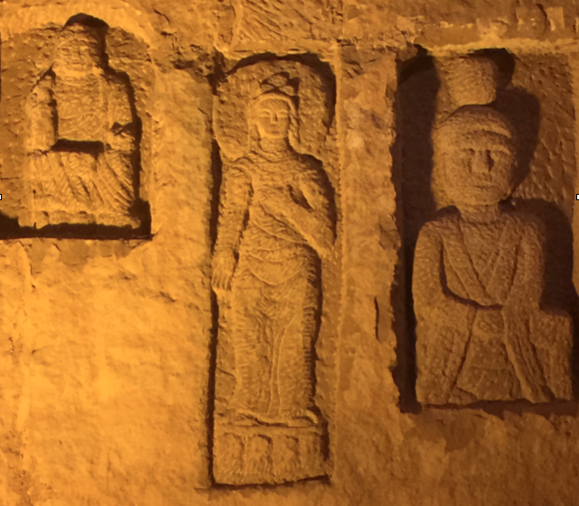
One of the key areas that I wanted to visit at Emei was a small temple at the base of the mountain beside the small Emeishan museum (which is located within a few hundred meters of the Xiujia Waterfall (秀甲瀑布).
Despite this temple being considered to be unimportant (due to its small size it is not marked on most maps), during renovations the temple grounds were disturbed and it was discovered that a far older temple existed just underneath the surface. The finds at this site have also been preserved and they can be seen by the public. More importantly, within two of the items recovered, there can be seen geometric patterns. The first is a large portable wheel upon which a series of parallel lines are carved, and the second is a carving on the wall of a goddess, which has a series of lines carved on the side of the deity.
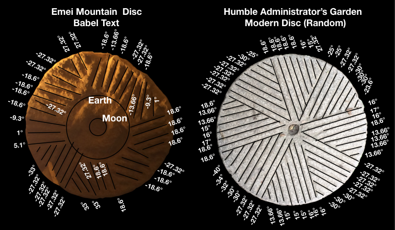
In this revised study, rather than collect all the angles as a table, which is both difficult to visualise and difficult to analyse, it was decided to present the data graphically, which makes it simpler to undertake a statistical analysis of the data and to determine the probability that the pattern is random or drawn with intent.
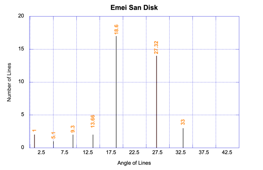
This graph is important, because it has already been shown that these specific angles are linked to astronomy, and statistically the chance of these lines being random is equivalent to tossing a coin 11 times in the air with the intent being it will land each time on its side, and you achieve that task on your very first attempt. This suggests the ancient temple was created by a civilisation that employed the Babel Texts in their ancient religion and temples.
Looking next at the Goddess Figure unfortunately, a reanalysis of the lines argues the lines are too short to be analysed with any degree of reliability. Though many lines do appear to be drawn as parallel sets, the lines would have to be at least twice as long to be able to generate any useful information.
Thus, at this moment in time, though the series of lines along the edge of the Goddess do appear to be linear texts, this cannot be proven and it would be conjecture to argue these lines are a prayer, or were attached to the image for some other reason.
Discussion and Conclusions
The primary result is that there is currently only one analysable artefact at Emeishan, and the structure of the lines present on the disc is consistent with the structure found in other ancient geometric images. With these lines already confirmed through statistical studies to be an archaic form of text, this indicates that the ancient disc may contain information that relates to the people who built this early temple.
References
- Derek Cunningham, The Babel Texts
- Derek Cunningham, The Map That Talked.


